Tuesday, July 7, 2015

Postcard from Croatia's Dalmatian Islands (postmarked 02 July 2015)


Eastern Europe.‎ It's not the like anywhere else on Earth. And Croatia, having been ruled by the Italians, the Slavs and others, in turn, over the centuries is a special place within Eastern Europe. Somehow, though, the Croats, despite what they have been through in just the past three decades, are a mighty friendly bunch, ready to help at every juncture. And nearly all are fluent in English, albeit with their own unique brand of accent. 

We went on six hikes during this holiday, roughly one every other day. Each successive one was increasingly challenging. The highlight was the fifth, the six-hour climb up Croatia's second highest peak, Sveti Jure, at nearly 1,800 metres above sea level. Many peaks here begin with the word 'sveti' so I had naturally assumed that it was the Croatian word for 'peak' or 'mount.' Only after a week did I notice that nearly all churches were also named Sveti something. Turns out that both churches and mountains are normally named after a saint and Saint Yuri won the title for our hike selection. There are several routes to the top of Sveti Jure and we chose what turned out to be the most difficult. Starting at sea level, in the town of Makarska where we had spent the evening and night before, we walked uphill through the town's suburbs to its outskirts and the trailhead. From the trailhead and for the next two hours we climbed the steepest slope of my hiking experience. Much of the slope was covered with rockslides and being too steep to hike up safely, it was criss-crossed with switchbacks, themselves so steep that we needed a break from the burning sun baking us from above and grilling us from below, and from our sweaty effort, every 45 minutes. A lone tree casting its shade across the route was all it took for us to call for a pause to eat and drink and rest. At other sections later on we had to leap from boulder to boulder to make progress. These sections are always fun and remind me of a childhood adventure that I might have enjoyed, but for which I am today grateful. For a welcome break, we also had to traverse flowering alpine meadows, lush with tall grasses bent over in the blowing breeze and peppered with pockets of whites, yellows and purples. And suddenly, it seemed, we were passing through a dense forested valley replete with birds flitting through the canopy above and a soft leafy bed beneath our feet. No difficult climb would be complete without some scrambling. Both arms and upper body strength were requisite in these sections of the route where it is necessary to hoist ourselves and backpacks, too, several feet straight up using rocks, crevices or tree roots as handholds The burning sun was relentless but fortunately the increasing elevation resulted in the air becoming cooler as we ascended... from 30C at the sea to 14C at the peak, the cool, thin air at the summit was indeed both refreshing and welcome. Even more refreshing is that because this mountain has a large television tower at the summit which requires regular maintenance, there is a service road from its base to the top, and, so we have an air conditioned taxi van waiting for us at the summit to whisk us back to town far below, all arranged two months beforehand!

The port town of Hvar on the island of Hvar has earned itself a reputation of being party-central for all of Croatia. Appropriately, ‎hotels, restaurants, cafes and all services cost nearly double compared to the rest of Croatia. In return we see the young, jet-set eastern Europeans at play. Thanks to a fortuitous twist of fate we are spending two nights at a $400-a-night hotel and get to partake, too, while in luxurious surroundings, enjoying scrumptious buffet breakfasts, cascading swimming pools with swim-up bars, a private beach and more. The town harbour is surrounded on three sides by numerous cafes and lounges that quiet down only at dawn. From what I can discern, most of the young revelers are drunk by 1am but stay out much, much later, likely requiring a review of selfies and friends' pics the day after to know how much they had enjoyed themselves the night before. Not judging, just saying. The hike that I had charted for this island took us through fields of wild lavender up to the higher reaches of the area. Unexpectedly, en route, we fell upon perhaps the world's only lavender festival, an annual event lasting two days in the tiny village of Velo Grablje. This town boasts a lavender mill where the plants are processed to produce their oils and essences. The next day we rented scooters and visited the other large town on the north side of Hvar, Stari Grad. Always to be remembered as the location where I enjoyed the best ice cream in Croatia, it will also be an overnight stop on my next visit to this country; besides the rich, cold, tasty ice cream, it is nearly void of foreign tourists, yet one can still rent a bicycle or charter a sailboat as well as choose from one of a couple of dozen quaint restaurants for al fresco dining along the picturesque harbour. One quickly becomes accustomed to, and thus forgets to explain, that every home, restaurant and shop in these ancient harbour villages was built centuries ago, by hand, from stone and mortar, with electricity and plumbing incorporated years later. The windows cut into the walls are ornate with carved perimeters, the cement railings along stairways and terraces are adorned with small statues, all the roofs are covered with the ubiquitous, Mediterannean, curved, red clay tiles. The streets in all the old towns are made from the same stone, worn smooth by centuries of pedestrian traffic. There are never cars in the old towns as even the widest streets are too narrow, but even so, motorbikes and scooters are forbidden. There are few street names and barely an assigned address in the old towns. Directions to a guest apartment or shop are given today exactly as they must have been two millennia ago, with a series of hand gestures and a reference to a clock tower or church. 


We went sailing on our first day in Croatia, around the Elafiti islands which spread north from Dubrovnik in the Adriatic Sea. Of Croatia's 1,240 Dalmatian Coast islands, 14 of them are Elafiti. One advantage of traveling in a group of ten is that we get to charter our own sailboat and so chart our own course!‎ We set sail for a nearby, uninhabited island, one which has an underground cave, that is to say, the cave is accessible by swimming under a natural arch made from the rock cliff above and entering thus. What I found uniquely exhilarating is that the daylight enters the inside of the cave by the underwater entrance as there is no other source of light. As a result our bodies are illuminated by an eerie blue light, but only from below. We all look like aliens to each other with a blue glow reflecting off our bodies, but only on the parts of our bodies that are underwater. The top of our cave is about ten metres above us and the floor is about the same depth below. The seawater is warm and buoyant making it delightful to swim and difficult to leave the sea and climb back into our sailboat. Did I forget to mention that here and everywhere else that we traveled, the water is unusually crystal clear? We can easily see down ten to fifteen metres and discern details on the sea floor! A little later, after sailing further north, we have docked at the smallest island fishing village, Sudurad on the island of Silovo Selo. It has only one cafe, where we all ate at a long table set up outdoors on their terrasse, shaded by a living roof made of a variety of flowering vines. This was to be the first of many, many meals shared by friends, at a long table with ample glasses of beer and wine, fish soups and salads, grilled seafood delicacies, banter and laughter, much like we often see in the movies wishing we could partake in the experience, too. Perhaps of all my memories of traveling through Croatia (and Montenegro, too), the ones of lunches and dinners will be the most savoured. We were without exception the only group to be living life 110%, from our midnight drinks on the top of a castles's turret in Korcula to our post cycling lunch at the Konavle winery south of Dubrovnik. How do I know? Because sadly, the majority of other diners spend a great deal of their mealtimes ignoring each other and their surroundings while silently texting somebody else somewhere else.

On that note, here's wishing you are living life, too, in whatever place you may find yourself today!!

Barry, now part Croatian, part Canadian

Tuesday, March 31, 2015

Postcard from Alpe d'Huez - 1,800 m elevation (postmarked 29 March 2015)

Hi!

‎There is no debating the unparalleled, spectacular views from Pic Blanc (3,330 m).  The colour of the sky is not just blue, but blue within blue; the snow capped mountains surround us 360 degrees around at varying distances, 10, 20 and even 30 km away, their peaks piercing the heavens and often caressed by wispy clouds. And the snow is not white but brilliant, bleached white, almost blinding. Notwithstanding the fierce struggles and tumult all around the world, it is eerily silent here, probably the same silence that a deaf person must experience. As though all this were insufficient, unlike anywhere else in the French Alps and for reasons unknown to man, there is most often a temperature inversion here, with the valley below our alpine village colder than above in the mountains, resulting in a blanket of clouds forming below our village, filling the valley completely. It seems as though our 240 kms of skiable slopes are on an island, suspended above a bed of clouds. Hence the name known locally, l'île de Soleil‎.


Now that I have diligently described to you our island of paradise‎, let's talk about skiing! What uniquely distinguishes this 'station de ski' is the 'hors piste' or off trail skiing. It is our guide's mission in life to steer us away from the groomed trails and into the most challenging descents accessible. We invariably start each effort by skiing under an out-of-bounds rope clearly identified with signs in several languages and various pictograms warning of the risks of falling off cliffs, skiing over rocks and getting buried in avalanches. Fair enough, but each of us is carrying a beeper in case we get caught and buried in an avalanche; and each of us wears a backpack containing a fold-up shovel and other instruments in case somebody else gets buried. Feeling safe, one by one we follow the leader, traversing along the very steep edge of a mountain, the left side rising seemingly vertically to its summit, the right side falling precipitously down to a nasty ending. Below my skis follow two narrow tracks as I concentrate on leaning very slightly left as I glide forward. Finally we arrive at a plateau. There are many at Alpe d'Huez and as we are far above the tree line, they are all barren, covered in virgin snow, interrupted by rocky outcrops which we navigate between.
This lunar landscape is most exceptional and disorienting, too, as the guide weaves his way forward and down, sometimes leading into a giant bowl 200 m long and equally wide where we can each find our own fall line to ski down fresh snow, leaving behind fresh tracks. Where he is ultimately leading us is to one of many couloirs, which are steep, narrow, snow-filled gullies, 300 or 400 m long, sometimes only as wide as the length of my skis‎, or so. Negotiating these narrow couloirs is as challenging as the sport can offer and I am frankly overwhelmed with pride if I manage the challenge well -- that is to say not every descent is as fluid and successful as I plan. 


This station claims to have the longest black diamond run‎ in Europe. My friends and I are good skiers but it still takes 15 minutes to get to the bottom which we normally save for the last run of the day -- the only run we make that is 'sur piste' or on the marked trails. The difficulty of skiing hors piste has its rewards: the shear pleasure of descending the mountain by way of the natural landscape, not always sure of where the next slope or turn leads. Incredulously, navigating the same vertical drop of 2,000 m as sur piste takes us over an hour. Once at the very bottom I am normally exhausted, beat up, overheated and blissfully ready to get back to Pic Blanc and do it all over again!

May all your runs take you downhill!

Pic Barry

Sunday, January 18, 2015

Postcard from Punta Banco (postmarked 13 January 2015)

‎No, you won't find it on the map. 

Serendipity and the invisible hand of fate conspired to steer me to the end of the road, to the furthest point south in Costa Rica, to a tiny community of a hundred persons: Punta Banco. Replete with a tiny, turquoise church, an even smaller school, a soccer pitch, four supermercados (each one smaller than the other) and a stretch of beach to which only a picture postcard could do justice. Palm trees caress the entire length of beach, their huge fronds swaying in the Pacific breeze, many of them hanging over at impossible angles, laden with coconuts waiting for a stronger wind or a machete's swipe, so that their nectar can be savoured. And behind the palms is the jungle, splendorous in colour thanks to the rainy season having just ended. The multi-hued birds of paradise and other flowers and orchids stand out brilliantly against their lush, green background of ferns and palms, mangoes and star fruit trees.
‎‎This is home for my friend, Gabriel, for several months each winter, and now it is mine, if only for two weeks. 


Yesterday, we rose at 5am to the screeching of howler monkeys. Our bare necessities cabinas are surrounded by verdant jungle on three sides‎ and these aptly named monkeys get a head start on the roosters to greet the new day with their howling. The local botanist claims that their noisy cacophony is how they mark their territory each dawn (and dusk) but my own theory differs: why would supposedly intelligent primates have to so frequently remind all the neighbouring intelligent primates of this same fact twice a day, every day? Surely they are simply welcoming the new day with a primate singalong . My alarm was set for 5:30am but that was a moot point a half hour earlier. It was no longer possible to sleep. We ate a home-cooked breakfast of eggs and rice and beans and headed out along the beach before 6am. There is something odd about a long hike which starts out on a beach. It seems as though I am casually walking along the beach as we have all done countless times. The waves are crashing repeatedly to the right. We can see the fisher birds squawking as they hover, searching for their breakfast just above those same waves which churn the fish about and bring them closer to the surface and to the birds' hungry beaks. When the locals see the birds feasting like this they scramble for their own fishing gear and join in. Farther overhead we see an impressive flock of pelicans flying in formation, although presently in a single undulating line, not in the expected V-formation. Even though we are 200 feet below them, we can see that they are very large and graceful, too, slowly flapping their huge wings to stay aloft. We are walking south so the sun is not yet shining on us, it has just risen and is blocked by the tall cliffs or mountainsides that often end on the beach, each one covered in palms, ferns and other tropical growth.
‎After an hour we cross a river emptying into the sea and then turn left and climb up away from the beach and into the jungle. It is still very early in the morning, the sun has yet to rise much above the horizon but the heat of the day and humidity have now begun to become  oppressive, especially since we are climbing steeply and perspiring. The trails we follow are known only to the indigenous who use them routinely to transport provisions up to their farms by horseback and to carry down the fruits of their labour to market. Our guide, Moe, is well known to the community as is every farmer and farmer's son for miles around. After several hours of uphill progress through the mountains, the farms and the jungle we have arrived at a small, unremarkable stone monument which denotes the border with Panama. We step into Panama and sit ourselves down on a log for a well-deserved Panamanian lunch! 

The trickle of cold water that claims to be my shower is no match for the creek behind the house. During the rainy season it earns its name of Rio Nicaragua but now the waterfall that feeds it ‎is hardly the torrent it was just one month ago. Bathing in the pool of fresh, cool, water at its base has become one of life's quotidian pleasures, cooling me down now so I can sleep comfortably later as I wash off the perspiration and salt of the day's activites. I can see parrots flying overhead in pairs, some with tails eighteen inches long -- macaws, apparently -- wings that seemingly change colour with each flap, first blue then green and then red, as their melodic songs drift down to me below. A four-foot long sloth lazily inches past on the riverbank, in no hurry at all to arrive at its destination, likely the branches and leaves of the mango tree that they adore to munch on. During yesterday's bath it was an anteater that ambled by, tomorrow I am hoping to see a jaguar as I bathe; it is the largest creature to inhabit these jungles. 

And so life goes on at the end of the road, hiking, biking, horseback riding, deep sea fishing, panning for gold, a class at the nearby yoga farm, the market in the nearest village, surfing and swimming at sunset -- the ocean is so warm and the waves are big!


The locals use a salutation here in the way the hippies of the '60s used to say 'Peace' or Spock's 'Live long and prosper' or even Yoda's 'May the force be with you.'
It is ‎'Pura Vida!‎' -- you could translate it as you want ("pure life?") depending if you lean more towards the hippies or the Yoda lifestyle. I think it's high time we had a more interesting salutation at home to replace the tired 'See you' or 'ciao' or 'salut' --  your thoughts...?

Barry

Sunday, July 13, 2014

Postcarta continua (postmarked 29 June 2014)


Buon Giorno again!
In the event you are unaware, I am leading four other intrepid backpackers on a hike from Amalfi to Sorrento over a seven-day period. On four of the mornings we hike up into the mountains with all our belongings (about 15 kg each) neatly stuffed into our backpacks, climbing rather steep mountains to an elevation of approximately 600 metres, then hiking parallel to the sea for about 10 km on paths that have evidently been employed for hundreds of years as supply routes until the arrival of the automobile 60 years ago. We then descend to the next seaside village and check in to the next hotel. On the other three mornings, when we spend two back-to-back nights in the same village, we have the opportunity to chart a hike higher up and further away, carrying only a lighter day pack, eventually looping back to our starting point.
From beginning to end we will have trekked over 100 km, with a total elevation gain of about 7,000 metres. If you see me soon after my return and I am limping, there will be no need to ask why!

As I was recounting recently, we had arrived at 1,040 metres elevation to find a large, abandoned monastery. A dense, cool fog had mysteriously rolled in (again) making it difficult to see and it began to feel like dusk even though it was barely 3:30pm. Locating the other trail which would take us down to Ravello was thus proving challenging when out from behind a small outdoor alter set high on a rock outcrop, there most suddenly and surprisingly appeared a skinny, Italian pilgrim with long dreadlocks, wearing a tattered friar's outfit. Until this moment, we hadn't seen another human since refilling our water bottles at the town fountain in Perogela. He reminded me of all the modern day portraits of Jesus Christ so his unscripted entrance in the monastery's vicinity seemed somehow fitting. He confirmed our choice of trails in broken English by reminding us to simply "go down, down" and then he quickly disappeared into the mist as if he were never there. Very strange.

Did I mention that the views from high up are breathtaking? Foggy periods excepted, every time a path takes a new twist or turn, a different vista is laid out before us: mountain sides fall away revealing small villages perched below on their faces, beyond which lie other villages further down one slope or another. Below those will appear a seaside village with improbable names like Minori and Maiori, with the shimmering Mediterranean sea lapping at its beaches or smashing into its cliffs. It is quite impossible to tire from the various views of the lemon groves and goat farms, the villages to which they belong, the sea always generous with its deep blue temptations, beckoning to us in the distance.

The hike downhill requires less effort normally, however we noticed that the clouds had become more ominous, the air was getting heavy again and we quickened our pace. We arrived in Ravello in no time and stopped in, famished, at the first restaurant that we stumbled upon. In just a few seconds it started raining and then only moments later the skies were booming with thunder as the rain intensified into a downpour fit for a jungle. It was our first of seven all-day hikes and the second of many lucky turns of events (remember the friar way above). The gods were looking out for us indeed!

Here's hoping that the gods are on your side, too!

Barry of Amalfi

PS. Before I let you get back to your everyday musings, I will share one additional good luck story. Upon arriving in Sorrento, we learned that the owner of the hotel, Biaggio, was a "world-reknown" chef and was in fact giving cooking classes daily at 4pm. People come from all over Italy and indeed from the world over to take a week or two of Italian cooking lessons. This is how I find myself, hands-on, preparing spinach gnocchi in pesto sauce from scratch, fried anchovies, eggplant parmesan and a chocolate dessert, too. The kicker is that the entire four-course meal is served to all the hotel guests who choose to stay for dinner. A long table is dressed on the hotel's front terrasse under the warm deep blue skies at dusk and 14 guests, Swedes, Germans, Americans and Canadians, are treated to the meal that I and two others have just prepared, under the watchful eye of Biaggio. Italia rocks!

Postcarta della costiera Amalfitana (postmarked 24 June 2014)

The day began as any other: by 7am, the Mediterranean songbirds' sweet melodies dance through the open windows and tango with my sleepy sub-conscience. At 7:20am, my phone alarm continued the process with a more startling melody, that is to say, I was now awake. One should really sleep later on holiday, how else to distinguish between it and the rest of the year? However this day would prove to be a long one. And getting an early start was well advised. We loaded up on breakfast, the cool Mediterranean Sea and brilliant sun our witnesses, and then headed out, our bodies laden with backpacks.

It was a humid morning, a telltale of what lay ahead. Even walking downhill the 3 km to Amalfi town rendered us all with a thin coating of hot, slick perspiration.

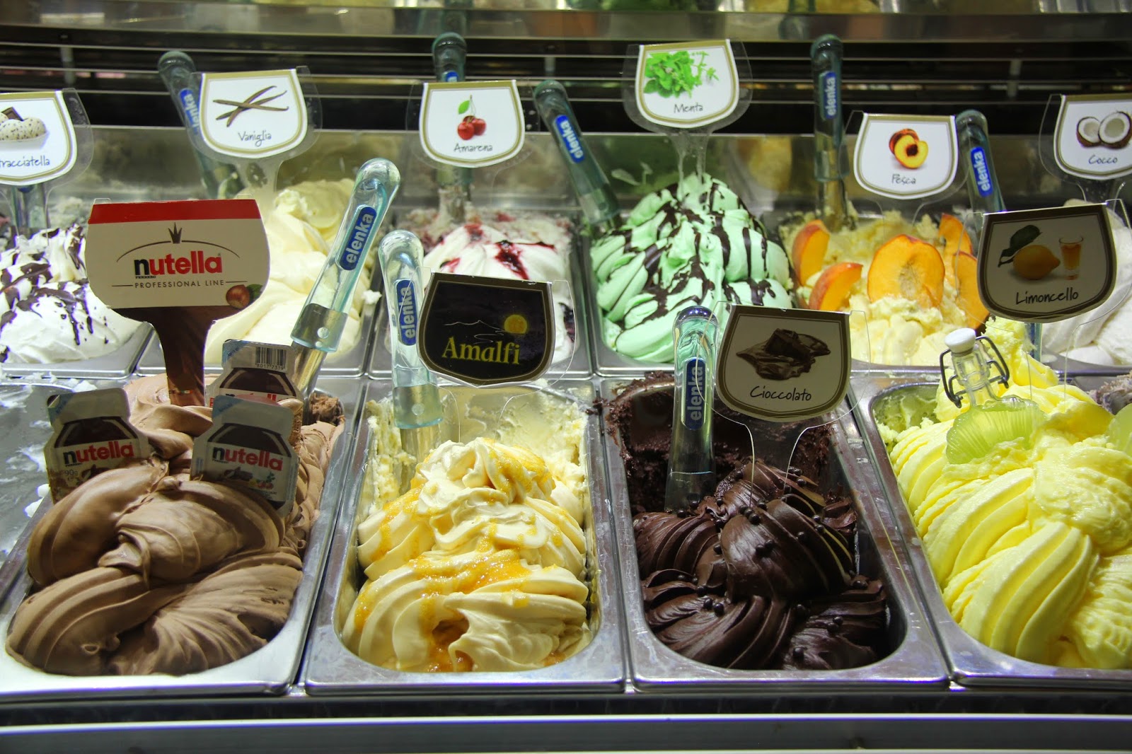
The center of Amalfi is a spider's web of cobblestone streets and alleys, all seemingly too narrow for cars, but it doesn't stop the smaller ones from squeezing through anyhow. Between them and the many scooters, pedestrians seem to be considered fair game: pay attention to the cacophony of beeps and horns or risk becoming a casualty. The maze of laneways is lined with tchotchkas stores, cafes, homemade gelato and chocolate shops, and restaurants each with its own terrasse. Unlike some other quieter tourist destinations, there are thousands of people jammed together here, each competing with the other for any given merchant's attention. Even the tiny fruit store had a queue of people waiting to be served. On top of that, we hear languages being spoken from all nationalities and with exception of the Americans, everybody is doing his or her best to speak in broken Italian. In the pastry shops even the least expensive offering is exquisitely presented, the tasty delicacies artistically stacked on top of each other behind glass counters. In the ice cream shops the gelati are displayed with such delectable care it is nearly impossible to choose just one flavour. My mouth waters in anticipation just by their presentation. My "go to" preference is always banana but it was the cherry 'amerena' that chose me today and it became my first gelato in Italy (this year). The richness of the flavour coupled with the creamy cool sensation on my tongue as I savoured the refreshment got me hooked (again). I now expect to be enjoying one each day.


Most of the hikes that start in Amalfi require you to walk through Amalfi town, north from the beach. After passing through the crowded shopping zone, we turned left into the most narrow alley and started climbing steps. I cannot remember being warned about this but we climbed several thousand ancient, broken stone steps without pause, through multiple lemon groves where lemons are the size of a small cantaloupe, until we reached the next town uphill, Pogerola. After a refreshing drink from the public fountain in the town square (why don't we have these at home?), we soldiered on.

The routes are not well marked at all so finding the way out of town required a small amount of guesswork, a mixture of advice from the townsfolk and a large dose of luck. We had planned carefully, each of us had a change of dry clothes, rain gear, food, water, extra water, a whistle, a map and a personal med kit, all just in case. Our day packs were loaded up. So you can imagine my shock when we met a solo 'hiker' wearing only beach tongs on his feet! He was 50 or 60 pounds overweight and carried only some water, no other provisions. He was waiting for us, or for anybody to appear, at an intersection, asking us from where we had come. Only then would he know whether he should choose the left or the right or return whence he came. The joke on us was that we continued throughout our week to meet hikers/walkers who appeared to be out for a stroll on the boardwalk, wearing sandals or beach shoes, even encountering an elderly couple high up on The Path of The Gods, the woman using a cane.

We continued hiking uphill, passing a herd of goats, shepherded by a big, protective dog who escorted us out of his zone of control. At this point we entered a rainforest with thousands of ferns covering the steep slopes which we were traversing. An eerie fog soon descended on us which shortly became rain and then a downpour and suddenly we could not see more than a few metres in any direction! Only one thing to do: find the thickest foliage and eat a well-deserved packed lunch under its protective cover!


This trail was not one that I had planned but it was too interesting for us to consider retreating. It became steeper, rockier and cooler as we ascended past 1,000 metres in elevation. When we reached the summit we arrived at an abandoned monastery straight out of medieval times: a wood burning stove in the kitchen, fraternal sleeping quarters upstairs, bunk beds intact and petrified wooden picnic tables outside arranged by a fire pit, recently used it would seem. After a break for some fruit and water we started down another trail which turned out to be a series of thousands of ancient, worn and broken stone steps.

Part II will follow next week....

Barry di Amalfi

Tuesday, January 7, 2014

Postcard from Northern California

Spectacular. Breathtaking. Heavenly.

Each of these adjectives aptly describes the vistas that I was fortunate
enough to gaze upon just last week. It was only a day or two earlier that I
was communicating from home with several Sierra Club leaders from the San
Francisco Bay area about the most rewarding nearby hikes. I judiciously
decided that the trail to Monument Peak would satisfy my need to breathe
some fresh California air from on high. As my recent thirst for hiking has
not yet been quenched, this choice turned out to be prescient. Unlike the
hiking at home, the Monument Peak trail, typical in the region, is
completely barren. Barely a tree to be seen, very few bushes, hardly a
clump of grass. No, we are not above the tree line, but the mountains that
define Silicon Valley, the Diablo Range to the east and the Santa Cruz
mountains to the west receive almost no rainfall, especially and
unfortunately in the past year. And so I am walking steeply uphill on a
dusty mountain side, under a warm, thirsty sun, always watching out for the
elusive mountain lion. He is here I am warned, ready to pounce on me from
that cliff above or from behind that next turn in the dirt path. My
longtime local friend, Dano, tells me that in all his years of hiking and
biking the surrounding mountains, he's only once seen a mountain lion, and
then from the safety of his car. Still, I am wary. The hike is steep. After
passing by dozens of cows grazing the rocky lower slopes in search of
moisture, I find myself above the layer of smog that blankets the valley
below. The bare, caramel-coloured mountains 20 km across the valley pop up
into sight. Unlike everywhere else I've ever been, the temperature here
climbs with the elevation, from 15C at the base to 23C at the peak. The
view has exceeded any expectations that I may have had. Contoured,
desert-like mountain ranges greet me on three sides, seemingly close by, an
illusion that I've witnessed before. A California condor soars overhead and
I wonder if it, too, has climbed 2,600 feet, like me, to gaze out at the
world in wonderment.

When you visit Northern California, remember this secret that I will now
share with you: the Elkhorn Slough (pronounced 'sloo') at Moss Landing. It
is here that I rented a kayak and paddled from the marina into the slough,
a swamplike area six miles long. There are over 300 species of birds living
here, some of them rather large such as pelicans and egrets. It is amusing
to watch the pretty, white terns circling above until spotting their fishy
prey straight below. Then they assume a streamlined shape by tightly
tucking in their wings and diving straight down into the chilly water,
emerging seconds later with their catch in their little beaks. But I am
saving the best for last: there are hundreds of seals, otters and sea lions
who live here in the protected slough. The sea lions are huge and scary but
they seem to spend their lives basking in the sun on the shore, bellowing
loudly and pushing each other around. Near them, it always smells like the
insides of a fish market. The seals are always swimming around, surfacing
anywhere at random, often surprising the paddlers nearby. It seems we
frighten them, too, as they quickly dive again only to resurface elsewhere.
But it is the sea otters who make me laugh out loud. They float around on
their backs, often in pairs, busily licking their little hands or munching
on whatever they are clutching. Otherwise they tease each other with their
otter games, like 'Guess Who is Behind You' or 'Tag, You're It,' I decide.
We are not supposed to paddle within one hundred feet of the animals, but
if they surface right next to my kayak, why not watch their frolicking from
up close and enjoy the entertainment?

I am sure you know that California is home to the famous redwood forests,
majestic trees that grow over many centuries straight up for a hundred feet
and more, often five to ten feet in diameter at the base. What you may not
know is that there are some redwood forests where you are welcome to cycle
through. One such place is the Nisene Marks state park, its southern
entrance located in the town of Aptos. Not just any park, the cycling trail
climbs 2,600 feet over nine miles. It doesn't sound like much of a
challenge but there are long stretches where many cyclists (the untrained,
I conclude) are forced to walk their bikes for it is nearly too steep to
pedal. Imagine yourself pedaling uphill for two hours with no respite. It
becomes easy to overlook the startling fact that I am winding my way uphill
in the midst of millions of immense trees. They block any chance of
sunlight from sneaking through the many branches and leaves far overhead.
It is only after 90 minutes that a break in the route brings me to a ledge
where riders can stop and gaze out for the first time at the forest below
and to the sea miles away to the southwest. As with my hike two days
earlier, it is much hotter here than at the mountain's base, a conundrum
still unsolved. Lest you think it is all hard work, remember that what goes
up must come down. Luckily, the brakes worked as advertised as it would be
deadly to attempt the return downhill without them functioning properly. If
you don't care to bike, many folks were simply walking along the same trail
as far as they cared to enjoy the majesty of the redwoods forest at a
slower pace.

Whether your pace is faster or slower, I wish you a happy, healthy and
sporty 2014.
Barry... the triathlete!

Sunday, December 1, 2013

Postcard from ADK - Cascade and Porter mountains

The morning was crisp, so crisp that my lungs burnt from breathing in the
fresh air too deeply. And the snow was dry and squeaked beneath my hiking
boots, tickling the soles of my feet. But the sun, the sun shone
brilliantly on my face, warming it ever so slightly from the frigid breeze
that greeted all early risers on this glorious day.
And thus I started my first hike of the winter at the base of Cascade
Mountain off of route 73 in New York state.
The trees, of course, are bare, their leaves have already changed to
brilliant reds and yellows a month or more ago and then blown free of their
branches in the brisk autumn winds. They lie now buried beneath the carpet
of snow that beckons to me this morning.
The trail is narrow, winding and steep: my favourite! At times, it is
obvious that the hiking trail is actually a creek, with cascading frozen
waterfalls acting as slippery steps allowing me to climb upwards. Makes me
wonder if this is how the mountain earned its name.
Some of you may not know that hiker, climber and skier aficionados all
affectionately call The Adirondacks, ADK, for short. There are apparently
46 high peaks in the ADKs and its every hiker's goal to summit them all. On
completing the 46th, there must be a celebration of sorts shared at the
peak by all those who have accompanied the champion, champagne or
chocolate-covered strawberries perhaps.
Now this may seem somewhat ridiculous as reaching the very highest and most
difficult ADK peak is akin to a walk in the park compared to The Annapurna
or Everest regions of Nepal or the 46 highest peaks within, say, The Alps.
But as the old saying goes, beggars can't be choosers, so the local
challenge and tradition remain just that and thus an accomplishment worth
celebrating. (I must inform you, for the sake of all ADK enthusiasts, that
some of the peaks require a 15-hour round-trip excursion -- ill-advised for
the beginner!)
Before long the forest of deciduous trees has been replaced completely by
conifers, their branches laden with snow. The trail narrows and ratchets
continually, left here, right there, so that one cannot see the trail at
all beyond a few metres ahead. It is a little magical -- it doesn't take
much to imagine that Bilbo Baggins's front door may be carved into that
immense boulder over there!
After an hour and a half we suddenly emerge from the forest onto a steeply
sloped clearing which provides us with a spectacular view of the valleys
below and the neighbouring mountains as far as the horizon and beyond. The
sky is brilliant in its blue-within-blueness and free of clouds treating us
to unparalleled visibility of 30 or 40 kilometers! I am elated! Really! So
much so, that I did in fact run back down a half-kilometer or more to
encourage the slower hikers in our group to hustle with the promise of the
awaiting vista.
I turned my back on the panorama and continued upwards, back into the now
stunted thicket of trees. Before long, I emerge for there are no more trees
at all. The final 500 metres is bald rock, with windswept, smooth surfaces,
seemingly piled on top of each other by a giant toddler. It is windy, cold
but I am nevertheless in awe of the majesty that surrounds me. Unlike other
summits, the absence of trees provides us with 360 degrees of all natural
beauty. Remarkable that there is no sign of civilisation in any direction
as far as the eye can see! Even stranger, perhaps due to the temperature,
neither a sign of life: not a single bird nor a mouse nor a rabbit. Lots
and lots of rabbit tracks, however, and a leftover carrot or two, but no
sign of the elusive creature.
Here's wishing all your days have their peaks, too!
Barry, the hiker who runs up and the runner who hikes down.
PS. 44 summits to go!
PPS. For the record we all managed to summit next-door Porter Mountain on
the same hike :-)